In today’s fast-paced world, precision and accuracy are paramount, especially in fields like agriculture, construction, surveying, and navigation. Enter Real-Time Kinematic GPS (RTK GPS) technology, a game-changer that has revolutionized the way we gather location data. This article delves deep into the world of RTK GPS, exploring its principles, applications, and benefits.
1. Introduction
Global Positioning System (GPS) technology has come a long way since its inception. It has evolved from a military tool to a ubiquitous navigation and location-based service. RTK GPS, however, takes GPS precision to a whole new level. In this article, we will demystify RTK GPS and explore its myriad applications.
2. The Basics of GPS
Before delving into the intricacies of RTK GPS, let’s revisit the fundamentals of GPS. GPS is a satellite-based navigation system that provides accurate positioning and timing information anywhere on Earth. It works by triangulating signals from a network of satellites to determine your exact location.
3. The Birth of RTK GPS
RTK GPS was born out of the need for even greater accuracy in positioning. Traditional GPS systems are accurate to within a few meters, but RTK GPS can provide centimeter-level accuracy. This leap in precision has opened doors to countless applications.
4. How RTK GPS Works
RTK GPS achieves its remarkable accuracy through a process known as carrier-phase measurement. It involves measuring the phase of the carrier wave from GPS satellites as it travels to the receiver. By comparing this phase with a reference station, RTK GPS can calculate precise coordinates.
5. RTK GPS Components
To harness the power of RTK GPS, you need specific components, including a base station, rover receiver, and correction data link. Each component plays a crucial role in ensuring accurate positioning.
6. Accuracy and Precision
One of the defining features of RTK GPS is its unparalleled accuracy and precision. It can pinpoint locations with centimeter-level precision, making it indispensable in various fields.
7. Applications of RTK GPS
7.1 Agriculture
In agriculture, RTK GPS is a game-changer. It enables farmers to precisely control machinery, optimize planting and harvesting, and reduce resource wastage.
7.2 Construction
Construction projects demand precision, and RTK GPS delivers. It assists in site preparation, grading, and ensuring structures are built with utmost accuracy.
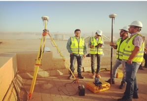
7.3 Surveying
Land surveyors rely on RTK GPS to create highly accurate maps and property boundaries. It streamlines the surveying process and eliminates guesswork.
7.4 Geodesy
Geodesy, the science of measuring Earth’s shape and gravitational field, benefits greatly from RTK GPS. It aids in monitoring tectonic plate movements and sea-level changes.
7.5 Environmental Monitoring
RTK GPS is crucial in environmental research. It helps track changes in glaciers, study soil erosion, and monitor wildlife habitats with precision.
8. Challenges and Limitations
While RTK GPS offers incredible accuracy, it’s not without challenges. Factors like signal interference and atmospheric conditions can affect its performance.
9. Future of RTK GPS
The future of RTK GPS looks promising. Advancements in satellite technology and data processing algorithms will likely lead to even greater precision and expanded applications.
10. Conclusion
In a world where precision matters, RTK GPS stands as a technological marvel. Its ability to provide centimeter-level accuracy has transformed industries, from agriculture to construction, surveying to environmental monitoring. As we look ahead, the future of RTK GPS holds even more promise, ushering in an era of unparalleled precision and accuracy.